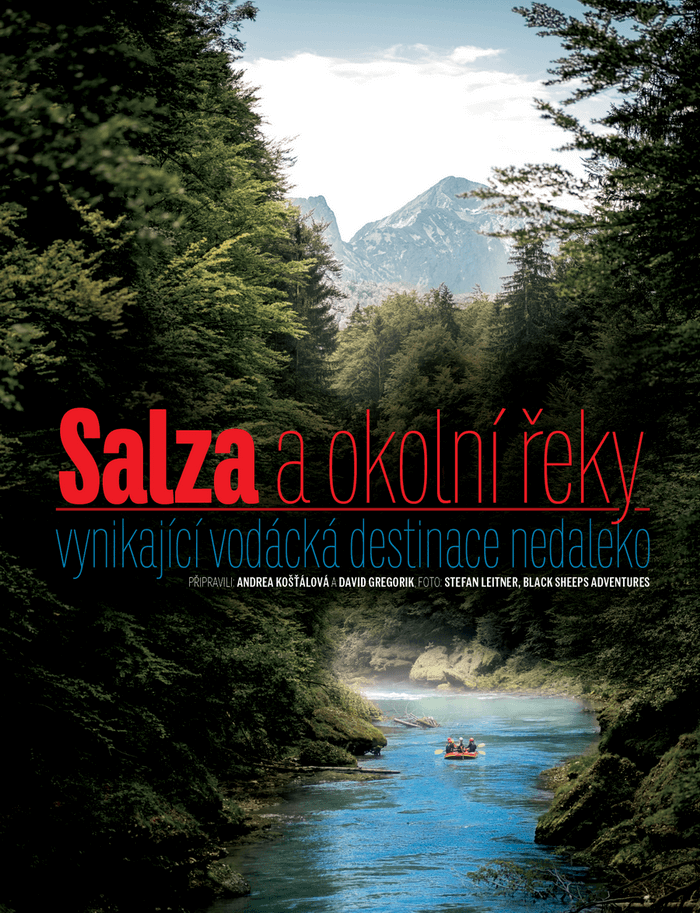
The Salza River – only few paddlers haven’t heard of it. Located in northern Styria, it flows between the Hochschwab Mountains and the Göstling Alps. Its source lies near the pilgrimage site of Mariazell, below Mount Ulreichsberg, at an altitude of around 1,800 metres above sea level. The river stretches for 80 km before joining the Enns. Crystal-clear water like this has become a rare treasure.
From its source to the village of Gusswerk, the Salza is more like a stream, so it is uninteresting for paddlers. From Gusswerk to the confluence with the Enns, however, 60 km of unforgettable experiences await paddlers in several sections.
USUALLY NAVIGATED SECTIONS OF THE SALSA
Gusswerk – Prescenyklause dam (Klausgraben)
After the village of Gusswerk, the first, lesser-known section of the Salza begins — a 15 km stretch rated WW I–II. It is usually navigable until June or after periods of rain. At first, the river runs close to the road, but after a few kilometers it veers off and winds through a stunning canyon. In the canyon, the water often crashes directly into eroded rock walls, and paddlers should be cautious of fallen trees in the current. There is also a hiking trail that follows the canyon, including a short via ferrata section near the river. The most common take-out points for this section are the village of Weichselboden or the Prescenyklause dam.
Prescenyklause Dam – timber floating
The distance is 1.2 km long and the maximum depth is 7.2 m. The dam wall is 47.5 m long, 8.5-15 m wide and 9 m high. The two side openings were used to float timber, the middle one to regulate the high water level. When both side channels were opened, up to 17m3/s more water flowed in the Salza and the water level rose by more than a metre. In 3.5 hours the dam was empty, but in the next 24 hours it was usually full again. In the Salza valley, timber was mainly harvested to meet the enormous need for wood for steel production in Eisenerz. Logging in the Salza valley dates back to 1373. The first dam used to float timber was built in 1750 near Gusswerk. The Prescenyklause as we know it today was built between 1841 and 1848 after the original wooden dam on the site had fallen into disrepair. In 1954, timber floating was stopped. In 1985-1987 the dam was reinforced and an additional tunnel was built with two turbines on the left bank, which today generate electricity for the town of Mariazell. This tunnel made it possible to keep the dam in its original state.
Prescenyklause – Wildalpen
This section is 16 km long and the difficulty level is WW I-III. For the first 10 km, the river flows through a wider valley with less gradient and spectacular views of theHochschwab massif. On this section you will meet fewer tourists, the river is rather shallow and difficult to navigate in low water on larger boats. The section is also suitable for children and less experienced paddlers.
Even more experienced paddlers, such as kayakers, will enjoy the Salza / F: Stefan Leitner
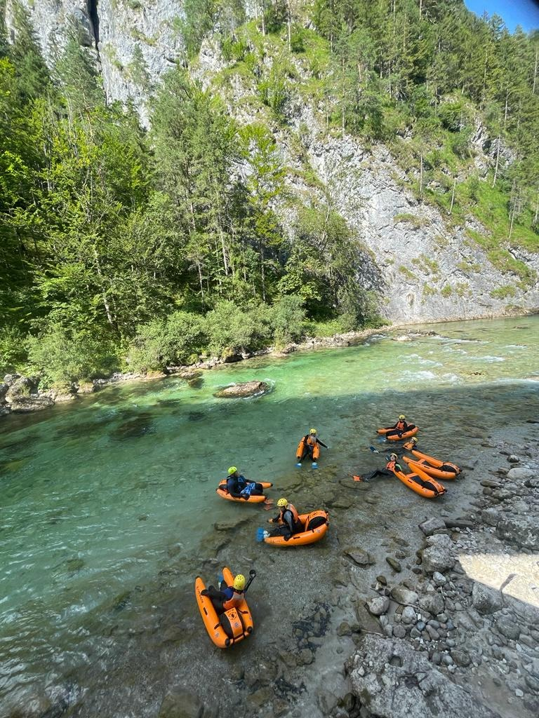
The last 6 km from the Brunn entry point, the river bed begins to narrow and the river becomes more technical. Especially at lower levels, there are a lot of rocks sticking out of the water. In higher water, solid waves and holes are created. A slightly more technical spot is the Nachbargauerwalze – a hole in front of the Nachbargauer campsite, about 3 km before Wildalpen, which can be partially avoided by choosing the left-hand passage. The ride of this section ends after the tributary of the Hinterwildalpenbach stream at one of the Wildalpen campsites.
The final pearl in Wildlapen is the so-called Heliwelli – the wave-hole, where rodeo competitions(Salzarodeo) are held every year. And those who still haven’t had enough can continue on to the slalom course with another wave-hole, where they certainly won’t escape the gaze of curious onlookers.
A popular cruise activity is jumping into the water / F: Black Sheeps Adventures
Drinking water from Wildlapen
After the first road bridge below the dam, where the road transitions from the right to the left bank (downstream), most paddlers will notice small streams and waterfalls flowing into the Salza on their left (especially after rain). Here is one of the many springs that supply Vienna with drinking water – Kläfferquelle. It flows into Vienna via an aqueduct with a flow rate of about 5m3/s, the excess drinking water is released into the Salza. More than 217 million litres of drinking water (also from other sources) reach Vienna every day. The transport system is 180 km long and the water takes 36 hours to travel. If you want to know more, there is a museum in Wildalpen where everything is clearly described (in German and English). A tour can also be arranged to the Kläfferquelle spring inside the mountain. More at www.steiermark.com.
Wildalpen – confluence with the Enns
The absolute most popular and most navigable section of the Salza is 22 km long and its difficulty level is WW II-III. The usual start is at one of the Wildalpen campsites. There are several alternative entry and exit points along the route, so it is possible to shorten the trip.
The first (easier) section is ideal for warm-up paddling. After about 6 km, the Lassing stream flows into the Salza at a spot called Fachwerk, which has been part of the “Wildnisgebiet” protected area since 2021—a conservation zone where nature is left to evolve with minimal human impact. Rafting in this section is strictly prohibited. Following the confluence, several rapids lead up to the final set before the Lawinenschwall (Avalanche Rapids). Just before these, the run can be made more exciting by diverting to the left (though access is difficult at low water levels) and paddling down the Moosrutsche (Moss Slide – watch out for wood!). We always recommend scouting the Lawinenschwall in advance—land on the sandy beach to the left. The rapid is navigable from all sides, but caution is needed around the central rocks, which are directly hit by the main current. At higher water levels, large holes can form here!
Also popular on Salza is Riverbug / F: Black Sheeps Adventures
After a few kilometres, there is another popular entry/exit point called Petrus (known among Czech paddlers as Galerka), from here the river is usually very crowded with rafts of local agencies, especially in summer months, so we recommend to get in outside the busy times (about 10:00-11:00 and 14:00-15:00). After a few hundred metres there is a very nice “Stangelgraben rapid”. The salsa narrows here and picks up speed for a while. You can expect big waves. Another pleasant stop is the approx. five-metre-high jump at theWasserlochklamm waterfalls, which offers the opportunity to cool off by jumping into the cold Salza, or to stop at the restaurant for stuffed potatoes and other local delicacies.
After the tributary stream from the Wasserlochklamm waterfalls on your right, be careful on the right-hand bend and stay on the inside of it (i.e. on the right). The water here encounters a partially undercut rock which is difficult to avoid at the last moment and more than one boat has been left wedged in. In the following kilometres the Salza begins to cut deeper into the surrounding landscape and the last exit point before the Palfaus Gorge is Erzhalden, commonly referred to as “The Stairs”. Here the unwritten rule of three steps applies – if only three steps or less are sticking out of the water, it is not recommended to enter the gorge!
The water in Salza is so clean and clear that you can drink it / F: Stefan Leitner
The Palfaus Gorge is the most beautiful place on the Salza, but it needs more attention. The rocks are undercut, sometimes a tree gets stuck somewhere. Swimming is not recommended here, it is usually very long. However, if it cannot be avoided, it’s a good idea to stay in the middle in the main current, think of the “floating leaf” position (i.e. as flat to the surface as possible with your feet downstream) and only scramble ashore where the gorge opens up and offers larger and safer eddies. There is one more unique opportunity in the gorge to jump off a rock about seven meters high. But be careful here! You must jump far enough away and only if you can see the water clearly. After high water, trees can get stuck here and jumping blindly would be a gamble with your life. In cloudy water, the edges of the rocks hidden underwater are also not visible.
The first possible starting point after the gorge is Saggraben – beware of limited parking! For those who haven’t had enough, there is the option to continue on to almost the confluence with the Enns River. The river already loses difficulty and speed due to the dam at the confluence with the Enns, but offers unforgettable panoramas of the continuing scenic gorge. Most paddlers disembark in Saggraben, so this stretch is a guaranteed romantic, crowd-free experience, also suitable for less experienced paddlers or, for example, beginner paddleboarders.
The next exit option is the Weiberlauf campsite or the last exit option – before the confluence with the Enns – Krippau (before the bridge on the dam on the right, however, it is not possible to park here – only for the purpose of loading and unloading boats). From the Weiberlauf campsite to the dam, however, it takes good muscle, the Salza almost doesn’t flow here anymore.
Salzaline parking
You need to buy a parking ticket for the section starting below Wildalpen, more specifically from the place called Brettetrbach to the confluence with the Enns (Krippau).You can buy it at one of the Salzaline partner locations – for example at the Black Sheeps Adventures guesthouse in Wildalpen (Czech and Slovak speaking owners, www.black-sheeps.eu). In the Wasserloch info centre, via the Easypark app and some car parks also have a parking machine. The ticket allows you to park in designated Salzaline car parks (no additional fees apply for rafting). The fees collected are invested both in the development of the infrastructure (car parks) but also in the maintenance of the entry and exit points. Salzaline is the agency that manages the land around the Salza (car parks, entry and exit points).
The fees are divided between private visitors and companies, who are obliged to report any commercial cruise to the Wasserlochklamm information centre and pay the appropriate fee(the price list for private users on the website does not apply to them). Up-to-date price information can be found at www.salzaline.at (also in English).
Rafting (over 3 persons) is subject to registration of the boat and IRF (International Rafting Federation) certified guides with the Landesregierung – Land Steiermark.
Remember safety
The Salza is a beautiful river suitable for the general boating public. Both beginner and professional paddlers will find their own here. However, it is important to keep safety in mind at all times and not to underestimate equipment or water conditions. We have been working as rafting guides on the Salza since 2013 and unfortunately we constantly meet paddlers without helmets, vests, without wetsuits, under the influence of alcohol, tying children to the boat or paddles, paddling in flood conditions with zero knowledge of the river and overestimating their own experience. These negligent actions increase the risk of fatal accidents and put other boaters and emergency responders in danger. So please, never underestimate the river and set an example for others! THE SALZA IS NOT A RIVER!
A detailed map of the Salza, available at various places around the river, will help you find your way around the river and you should always check the water level before setting out, available online here: https://www.ennskraft.at/Pegelwerte/Wildalpen.
But watch out! The state is measured in Wildalpen. There are many other streams and rivers flowing into the Salza before the gorge, so this is purely indicative (especially after rainfall) and should not be used to judge the navigability of the whole river, especially its lower sections. If in doubt, consult local paddlers, they know the river best and will be happy to advise.
ACCOMMODATION AND ACTIVITIES
Accommodation available Czechoslovakian guesthouse in Wildalpen offering rafting, canyoning, riverbug, kayak courses and rental of paddling equipment.
Canyoning in the Area Around the Salza River, there are several smaller creeks ideal for canyoning (pronounced “canyoning” – not to be confused with canoeing). This water sport combines adrenaline, fun, and personal challenge all in one. Canyoning means jumping into crystal-clear pools, sliding down natural rock chutes, and rappelling down waterfalls using ropes. ⚠️ But don’t go alone unless you have the necessary skills and experience. For a safe and unforgettable adventure – in your native language – check out: 👉 https://black-sheeps.eu/cs/typaktivity/canyoning/#faq
NAVIGABLE TRIBUTARIES OF THE SALZA AND THE ENNS RIVER
Hinterwildalpenbach
The stepped creek from Hinterwildalpen to Wildalpen stretches for 6 km and features around 70 drops, ranging from 0.2 to 3 meters in height. Its difficulty is rated at WW IV–, depending on water levels. It is only navigable during high water, typically in spring or after heavy rainfall. Expect a few tight switchbacks and limited options for scouting or portaging. Some steps are damaged and may form siphons, while holes and hazardous pools. Parts of the run can be visually scouted from the footpath that runs parallel to the stream. The most commonly paddled section starts at the bridge near the turn-off to the sauna and continues down to the confluence with the Salza River. Recommended only for experienced, professional paddlers.
Lassing
The river flows through the Wildnisgebiet Dürrenstein-Lassingtal (UNESCO) and has been officially closed to kayaking and rafting year-round since 2021.
Enns in the Gesäuse National Park
Enns can be divided into several parts in these places.
Gesäuseeingang (WW IV–VI, 1 km) This is a very challenging and congested cataract, clearly visible from the road. It’s suitable only for expert paddlerswith solid skills and experience in extreme whitewater.
Gstatterboden Section (WW II–IV, 8 km) Also known as the Raftingstrecke or Bierstrecke, this section starts below the cataract just upstream of the railway bridge, on the river’s right bank. Shortly after the put-in, you’ll encounter a small island—always go left! The right channel contains a dangerous siphon. At higher water levels, the main current tends to push toward the right, so less experienced or physically weaker paddlers are strongly advised to start below the island. What follows is a longer, more relaxed stretch—though bigger waves may appear depending on the water level—accompanied by stunning views of the Hochtorgruppe massif. On river left, it’s possible to take out behind a gravel beach and walk into the Bruckgraben canyon. Please respect local regulations and access restrictions—boats must be left just below the beach, as protected birds nest in the area. The take-out is possible either after the Gstatterboden road bridge or further downstream after the final cataract. As always, we recommend scouting the left line in advance—it’s usually passable on that side.
A raft from one of the local agencies sets out for an afternoon float / F: Black Sheeps Adventures
Kummerbrücke (WW IV–V, 6 km). This section starts just below the Kummerbrücke parking area. The first 600 meters are intense, with a steep gradient and massive holes and waves at high water levels. The key features include the so-called Schlitz—which can be bypassed at higher flows—and immediately after, a two-meter river-wide drop. Never go left here! The line is dangerous on that side. If in doubt, you can portage on the right bank.
The first section can be skipped entirely. About 600 meters downstream from the usual starting point, there’s a small parking area near a roadside cross, where you can access the river and put in on the easier part of the run. However, be aware that crossing the railway tracks here is prohibited and may result in a fine. The key feature of this easier stretch is the so-called Hartels S, located just after the Hartelsgraben road bridge. It’s highly recommended to scout this spot—at higher water levels, a siphon forms on the left side, and trees are often caught in this section, making it potentially dangerous.
This article was created with the support of the Gesäuse National Park, which has been responsible for managing the Wildalpen region and the Salza River since autumn 2018. The National Park offers a wide range of summer and winter activities for everyone—from families with small children to adrenaline-seeking outdoor enthusiasts. Visit www.gesaeuse.atfor a complete overview of activities, accommodation, attractions, and useful information about the region.
About the authors
Andrea Košťálová and David Gregorik are adrenaline enthusiasts brought together by their shared passion for mountains, water, and nature as a whole. Since 2013, they have been working on the Salza River as rafting, kayaking, and canyoning guides. In 2016, they took the leap and founded their own outdoor company — Black Sheeps Adventures KG — based in Wildalpen. Since 2018, they have also been running a Czechoslovak base and guesthouse in Wildalpen, offering accommodation and outdoor experiences.
Poslední dobou jsme narazili na spoustu dotazů na nesjízdnost Salzy. Velmi často zmiňovaný web raft.cz udává, že Salza je pod 135 cm nesjízdná, což není pravda. Na Salze raftujeme už 10 let a nestalo se, že by se (minimálně spodní úsek Fachwerk – Saggraben a dál) nedal jet, a to i na raftech. Samozřejmě zmizne…
The village of Wildalpen, located at the northern foot of the Austrian Hochschwab mountains, and its surroundings are well known to the boating public, especially thanks to the Salze river. In winter, a blanket of snow covers the landscape, turning the local slopes into an undiscovered paradise for winter hikers and ski tourers. Wildalpen is…
Photo: Stefan Leitner The Salza River – few paddlers have not heard of it. It is located in northern Styria and divides the Hochschwab and the Göstling Alps with its course. It rises near the pilgrimage site of Mariazell below the Ulreichsberg at an altitude of about 1800 metres above sea level. It is 80…
Od 12.6.2021 mají všichni pádleři sjíždějící Salzu soukromě (tedy ne firmy) možnost využít tzv. BootsTAXI. Jezdí o víkendech a svátcích zhruba v jedno až dvou hodinových intervalech (časy je třeba brát orientačně, můžou se lišit dle četnosti vykládání a nakládání vozíku loděmi). Po cestě Grossreifling – Wildalpen – Grossreifling se pak nachází vícero zastávek. Každá…
Cookies & Privacy policy
To provide the best experiences, we use technologies like cookies to store and/or access device information. Consenting to these technologies will allow us to process data such as browsing behavior or unique IDs on this site. Not consenting or withdrawing consent, may adversely affect certain features and functions.
Functional
Always active
Technical storage or access is absolutely necessary for the legitimate purpose of enabling the use of a specific service that the participant or user has expressly requested, or only for the purpose of carrying out the transmission of a message via an electronic communications network.
Preferences
The technical storage or access is necessary for the legitimate purpose of storing preferences that are not requested by the subscriber or user.
Statistical
The technical storage or access that is used exclusively for statistical purposes.The technical storage or access that is used exclusively for statistical purposes.
Marketing
The technical storage or access is necessary for the legitimate purpose of storing preferences that are not requested by the subscriber or user.


 Okolí Salzy je vhodné také pro canyoning. / F: Stefan Leitner
 About the authors